

I: Iceland
Reykjavik.
left: The Icelandic flag.
There is a regular bus service by Flybus, the bus company associated with Iceland Air, who will drop you off at your Reykjavik hotel for around $9 per person. Or, you could take a taxi and pay $90. But, to make things easier, a representative from Great Canadian Travel was waiting for us. The poor guy must have rolled out of his warm bed at 4 in the morning to be there at the airport in time. It was just before 6:00 a.m. and the country looked cold and desolate. It was around 50˚F and there was just a light wind. For Iceland, this is beautiful weather. Along the road we saw an electronic display with three sets of numbers. One was the air temperature, the other was the temperature on the surface of the road, the third showed the velocity and the direction of the wind. Traveling can be hazardous in Iceland and these numbers tell you when to be extra cautious.
Peter Lieberman, a friend of ours, had told us that when they were in Iceland earlier this year, the wind was blowing so hard they could barely get out of the hotel just to walk outside. And a tour book helpfully reminded us that in January, Reykjavik enjoys an average of only three sunny days, and in July only one.
Apparently it is quite common to have fierce, wind-driven rain, alternating with drizzle, gales, and fog to create a miserable climate. The saying is that “if you don’t like the weather, wait five minutes, it will probably get worse”. What we found out is that because of the wind, weather patterns can change very rapidly. It may be sunny for a few minutes before rain clouds sweep in for a short and nasty shower, followed by another few minutes of glorious sunshine.
Geologically speaking, Iceland is fairly young and rugged, with snowcapped peaks, glaciers, hot springs, geysers, active volcanoes, waterfalls, icecaps, tundra, lava deserts, and craters. It is a beautiful country, especially when the sun is shining. And the atmosphere is clear, because there are few particulates in the air. The wind blows all the smoke and haze away. Almost all of the home heating is achieved using the heat from high-pressure steam from underground hot springs, which is transported through underground pipes throughout the city, at least in the major cities. You open the faucet marked hot, and out comes hot water with a taste and odor of sulfur and brimstone. It comes to you straight from the bowels of the earth, reminiscent of the brew of Macbeth’s witches. But then you open the cold water tap, and the water coming out tastes wonderful, because it comes from uncontaminated glacier-fed lakes. This is the yin and yang of municipal water supply. The surfeit of heat means in the country that there is little fossil fuel being burned, except in automobiles. And high taxation makes fuel expensive and discourages excessive consumption.
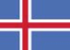
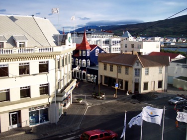
right: A quiet street in Reykjavik in the early evening.
In Iceland most of the people live around Reykjavik, the capital of the country where, as the guidebooks imply, there is a hopping and thriving night life. Still, the Icelanders are a hardy lot, and even in this harsh environment they have managed to become the 7th richest country per capita in the world. And they have achieved this in only the last few decades. The average salary is now around US$40K/year. This is actually amazing, since 60 % of their income is still from their fishing industry. But like everybody else, they are now pushing technology, management consulting, and tourism to increase their economic base. Tourism is doing well, especially with all the specials from Icelandic Air; it now accounts for around 20 % of their economic base.
Hotel Fron, where we stayed, was located in downtown Reykjavik. The room was not very large, but it was friendly and it was furnished as an apartment with all the amenities thereof. It had a large picture window and it looked out on the inner courtyard, so you had to pull the drapes for privacy. But the average Scandinavian is not as uptight as the average American. It was too bad we could only stay there one night. The location was very convenient, as we were able to walk and enjoy the sights of downtown Reykjavik. There is Lake Tjornin, which is a nice and pretty good-sized lake right in the middle of town. They skate there in the winter, but it wasn’t that cold yet at that time, thank God.
In the middle of the city is also the Hallgrimskirkja cathedral, a monolithic structure evoking images of lava flowing down from the rims of a volcano.
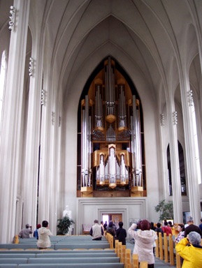
left: Interior of the Hallgrimskirkaja Church, the largest church in Iceland.
Looks like everybody in the church is a tourist taking pictures of the modern organ.
We also took a half-day excursion to see some of the sights outside the capital. The country is well-geared for the tourists; there are many travel agencies in Reykjavik where you can choose and discuss the possibilities of a variety of tours in English, German, or French. Or Icelandic, if you are so inclined. I don’t think I picked up any Icelandic words when we were there, since everybody spoke English and Icelandic was completely incomprehensible, even with our knowledge of some foreign languages. The half-day tour was $65/per person. Everything is expensive.
The tour took us through mountainous landscapes with alternating rain and sunshine; pelting rain for a few minutes followed by bright sunshine next. There was a good wind. The guide said this was good weather. We should have been here last week, said the guide, when there was driving rain almost all the time.
Þingvellir
First stop was Þingvellir, location of the country’s first parliamentary site, established around 930 AD. For many decades the Icelanders seemed to have come from all over the island to that location to discuss and establish laws and rules. The rocky surroundings do make for a dramatic backdrop. The reason for this remarkable landscape is because here one can clearly see the effects of the continental drift.
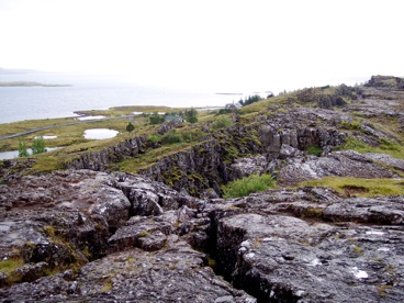
left: Þingvellir with lake Þingvallavatn in background
Right here is the boundary, running north-south, where the American continent is moving west and the Afrasian continent is moving East. They move away from each other at a rate of 2 cm/year. The results of these movements can be observed as growing cracks in the soil. The biggest crack is now a deep lake, lake Þingvallavatn, the biggest sweet-water lake in Iceland. You can see this lake in the background of the picture. The west bank, on the other side of this lake belongs to the American continent; the east bank, where this picture was taken, is on the Afrasian continent. The movement of the earth creates these huge cracks everywhere in the rocks.
The drift also causes the cross-section of this lake to be V-shaped, because the surface moves faster away from each other than the soil deeper in the ground. It is 120 meters deep in the middle and interestingly, over the centuries, three different species of trout developed in these waters. One species stays on the bottom and became bottom-feeders; another species stays in the middle depths of the lake and feeds on plankton and other small fry, and the third species became top-feeders and stays close to the surface of the water, feeding on insects and other stuff falling on the water surface. The 120 meters height is apparently sufficiently distant to allow for the development of these three different species.
Everywhere in the desolate landscape you see these cairns of stone as shown in the picture on the right. They were used as road markers in the old days.
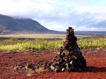
right: A cairn used as road marker as well as a mail box.
If you wanted to mail a letter to somebody, usually written on a piece of leather, you write his name and address on this letter, together with your message. A traveler coming by sees the letter and the address. If he is going into that direction, he takes the letter along to deliver to the addressee, or leaves it at another cairn if his path would veer in another direction. And so the letter will travel until it reaches its destination. It is probably just as (un)reliable as the US Postal Service.
.
Gullfoss
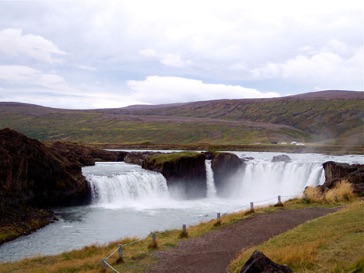
Gullfoss (The Golden waterfall) is Iceland's most famous waterfall, maybe because it is close to Reykjavik, so there are lots of tours going there. It is part of the glacial river, Hvita (White River). This enormous white glacial cascade drops 32 meters into a narrow canyon, which is 70 meters deep and 2.5 kilometers long. It has a spectacular two-tiered cataract and the fine drizzle above the falls usually results in a rainbow in the sunlight.
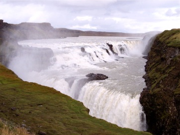
left: Gullfoss, the Golden Waterfall
There is a footpath from the car park, which runs alongside the northern edge of the falls to a viewing platform very close to the thundering waterfall. The air is filled with moisture and because of the constant humidity, the entire area around Gullfoss is wet and the surroundings are covered with lush vegetation.
Earlier, Gullfoss was part of a nearby farm, Brattholt, owned by the farmer Tomas Tomasson and his daughter Sigridur Tomasdottir. Foreign investors were close to buying Gullfoss to harness it for electricity generation and also charge visitors a fee for viewing. The farmer and his daughter took the case to the parliament, and Sigridur even threatened to drown herself in the waterfall if the deal went ahead. The government intervened, purchased the falls, and allowed the falls to stay as it was. Maybe I should say a few words about Scandinavian names. From his name you can derive that he has a dad named Tomas; that is why his last name is Tomasson, the son of Tomas. Sigridur’s dad is also a Tomas, so her last name is Tomasdottir, or the daughter of Tomas. So it is possible to have a family of husband, wife, son and daughter, all with different last names.
Hot Stuff
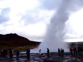
right: The geyser shown on the right spouts once every three-five minutes
Iceland is now the largest grower of bananas in the Northern hemisphere! Chiquita does not really have to worry, because with the high labor cost in Iceland, we’ll never see them as being able to compete against the $0.99 for a 4 lb bunch of bananas we see in Costco.
left: “tropical” spot in one of the steam-heated hothouses close to Reykjavik.
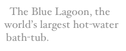
The Blue Lagoon
On our way home, the plane had a stopover in Keflavik Airport for a few hours –I think they planned it on purpose— and we took a trip to visit the Blue Lagoon. There was a bus ready to leave half an hour after the plane arrived and they assured us they would be back in the airport at least one half hour before the plane would leave. If you do not have Icelandic currency, there is no problem. They take Visa, MC, American Express, US dollars, or Euros. If you don’t have your swimming togs, this is fine too. You can rent them at the Lagoon. If you are hungry after the swim, there is a restaurant there too. They make such a big fuss about this premier tourist venue, you have no choice but to go and see it for yourself. Otherwise you will have feelings of guilt for the rest of your lives.
The Blue Lagoon is undoubtedly the world’s largest open-air bathtub. First they get high-pressure steam from underground and use this to run steam turbines to generate electricity. The waste steam and hot water from the geothermal power plant is then directed to this huge man-made swimming pool, 2-5 feet deep all over, where the water is a comfortable 90-100˚F all year round. With air temperatures often 40˚F and below, the pond would have cooled down rapidly were it not for the huge amount of hot water and steam being constantly fed into the pool. The water is full of minerals and is colored blue. There is a lot of volcanic rock around. You can see huge amounts of white sulfur particles floating around. It is actually quite pleasant to soak yourself in the warm water, especially on chilly days. What would have been useful is a pair of rubber thongs to walk from the dressing room to the pool and back and not to have to stand on the wet, cold floor, when you get dressed.
.
Driving in Iceland.
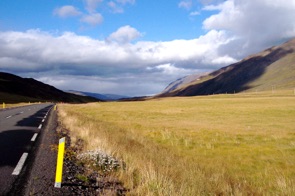
right: landscape along the road to Akureyri,
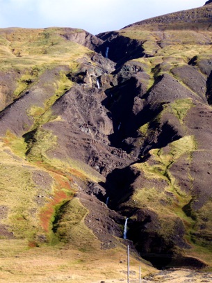
left: Low mountains and a cascade of waterfalls along the road to Akureyri.
We had gorgeous weather; mostly sun, with just an occasional shower. Sheep and lambs were roaming freely all over the place, as well as the Icelandic horses and an occasional cow. The Icelandic horses are small and sturdy and they seem to have cultivated a natural five-step gait, which is smoother for the rider than when riding a horse with the usual 3-step gait. I suppose it is like driving a car with 5-cylinders or driving one with 3 cylinders only.
Akureyri
Akureyri, also called the “Capital of the North” reminds some of us of a village in the Swiss Alps. The city is elongated and built along the Eyjafjőrður fjord. It is surrounded by high mountains, on which I counted at least 7 hanging glaciers when viewed from across the fjord. They should have made Akureyri the capital instead of Reykjavik. The town has a surprisingly mild climate; the temperature is almost always several degrees higher than in Reykjavik and there is much less wind. Many people from Reykjavik actually fly in here to spend the weekend to enjoy the nicer weather.
left: Akureyri as seen from our hotel room..
The city has a population of only 16,000 souls, but an estimated 180,000 tourists visit the town and the surroundings each year. With such few people around, the city still manages to have a symphony orchestra, several museums, several art galleries, and a fully operational 18-hole par 71 golf course. Everybody has at least two jobs to cover the many demands of the city. Jaðarsvőllur, located only 60 miles from the Arctic Circle, is the most northern golf course in the world. In the summer you can play straight through midnight, and some of the tournaments organized there are actually designed that way.
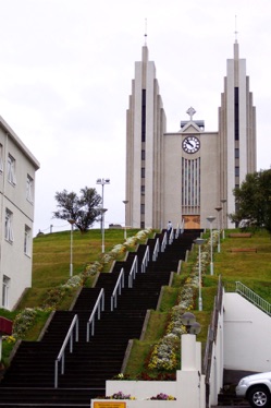
right: The church of Akureyri, designed by Gudjon Samuelsson and consecrated in 1940.
Food is expensive in Iceland. In a supermarket a 2 feet long baguette was $3. In sit-down places a 9” pizza was $15. Get a pint of Tuborg draft and you are out 8 bucks. There was a Subway franchise in Akureyri with the same layout as the ones we see here in the States and the cheapest Subway sandwich was around 10 bucks. But in the hotels the breakfasts were good and included in the price of the room, so that is where we loaded up. Having a car also allowed us to picnic for lunch. And in Akureyri we did find a Denny-type restaurant where we could have a simple dinner for around $20 per person.
Goðafoss
left: The Fall of the Gods.
Upon his return home, he took the likenesses of the pagan gods he used to worship and dumped them unceremoniously into a waterfall near his homestead. That guy knows how to take matters in his own hands. From that time, the waterfall has been named Goðafoss. This just proves it is useful to have a waterfall in your back yard.
Another 50 km further to the east and we were in the Lake Myvatn region. Lake Myvatn is shallow and is very unusual because of the many volcanic activities associated with the area. In Skútustaðir, for instance, there were a number of little hillocks sticking out of the lake, 50 feet or so high, and with diameters of around 100-200 feet. These hills consist of lava, which had been transformed into black pumice over the centuries. On most places there is a thin covering of soil and grass, but there are many places where the black pumice is open to the air. There is also a surprisingly large number of insects and bugs around, which does detract somewhat of the enjoyment of the unusual landscape. We were in an intermittent light drizzle, so that did keep the insects away.
Dimmuborgir
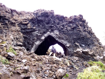
right: The Kirjan in Dimmuborgir
It is believed that these pillars were formed when steam rose through the molten lava and cooled it. An interesting formation is a huge cave in the solidified lava, named Kirjan for church.
Námaskarð
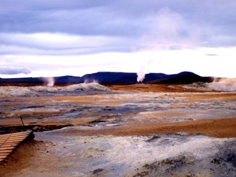
left: Steam vents, fumaroles, mud pots, and lots of insects.
These are really aggressive insects and even after being drenched in Deet, we were glad to be able to find refuge into the car where we were shielded from the flying terrorists; except from the ones who managed to sneak inside the vehicle.
Dettifoss
Going further east, we made a detour on road 864.It was 28 kms one way, on a very rough road, to get to Dettifoss, another waterfall. This one was harder to get to but it is also the most impressive and the most spectacular waterfall in Iceland. We found out, after driving carefully at 15-20 mph over this bad road, that there was much less jarring if we drove at around 40 mph, flying over the rubble, as it is.
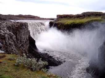
right: The Dettifoss waterfall.
Seyðisfjördur
Our final destination in Iceland was Seyðisfjördur, a little town on the East Coast of the country, which is the ferry terminal for the ferries going to the Faroe Islands. The town also has a small fish processing plant, but otherwise it is just a small town for people going on the ferry. Nevertheless, everywhere you go in this town, you find this appealing glossy brochure of the town, inviting you to visit and enjoy the amenities and the surroundings, put out by their Chamber of Commerce. I wonder how many people actually have gone to this place for vacation based on this brochure. I suspect it would not be very many.
The town has two restaurants, but the prices were so outrageously high, we stopped at the Shell service station where they had an eating area and where they served a tasteless (frozen) chicken hamburger and fries for around $15 per portion. You can get tomato ketchup, if you wanted to. I saw a family of four with two kids, maybe 6 to 8 years old, and they each had the hamburger and fries plate. That is an expensive dinner for them, and they actually left most of their food uneaten. What surprised me is they could have ordered three portions and shared the food, and it would have been more than adequate. But we noticed that almost nobody shares the food they order in an eating place. They don’t have doggie bags for the leftover food either.