The Caribbean Pond

IV: Tortola, St. Kitts, Barbados and St Lucia.
(a) Tortola
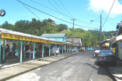
Tortola is a the largest and also the most populated island of the British Virgin Islands, east of Puerto Rico. It is a small, but very hilly island with an area of only 24 sq miles. Local tradition claims that island was first named by Christopher Columbus as Tortola, the Turtle Dove. Population of the island is around 24,000. Financial services and tourism are the main sources of income to the islands. This is the place where you can create illusionary partnerships and shadow corporations to establish a roadblock for those who want to know more about your finances.
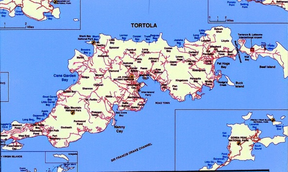
The draft of the QM 2 was too much for the harbor, so we had to anchor at some distance from shore and then tendered in. Tortola is quite popular with cruise ships, so nowadays thousands of passenger descend on what was at one time a very sleepy island. For tourists the de facto currency is the US $. The local currency is also denominated in dollars and is worth about half the US $. This makes it convenient for the shopkeepers, because they can put up a sign for so many dollars for a particular item. If a tourist comes by, the price is US $. For a local, he/she pays the amount in local dollars. The fact that these shenanigans make some items expensive is of no concern; the tourists will pay anyway.
We rented a 2-door Suzuki sport from International Car Rental for US$ 55/day. By the time they added insurance, tax, and gas, the total was $91. We probably should have just joined a commercial tour of the island.
left: the ferry house at West End. Ferries go from here to the adjacent islands.
We drove in the direction of West End, but the road was bad, so we crossed the island to the north and then drove along the shore, passing Long Beach Bay, Apple Bay, Carrot Beach Bay, and finally, the big one, Cane Garden Beach.
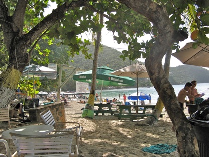
Traffic was on the left, but driving was not difficult, because the road deck was not conducive to racers. Cane Garden Beach was just a piece of sandy shore with picnic tables in the shade alongside. A lady was selling food from a small stand, and we purchased a plate of conch stew and “dirty” rice in a curry sauce for US$ 15. There was no other place nearby to get food. She wanted $5 for a coconut. These prices may well be in local currency, but since we looked like tourists, we were charged in US$. And with us, most of the other visitors to the beach. Locals don’t go to this beach; they know better.
right: Cane Garden Beach.
Sugar cane used be a major commercial crop here. But growing cane is not economical any more and so the fields are neglected and the cane grows like weed. There are some smaller areas where the plant is still cultivated, specifically for the production of rum.
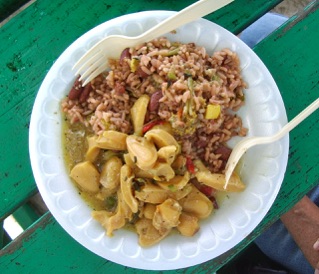
left; And this is the plate of conch stew and “dirty” rice, priced at US$15 for the tourist.
(b) Basseterre, St. Kitts.
Our ship had arrived here at 7:00 a.m., after leisurely steaming the 170 nautical miles from Tortola. The harbor is very deep, so the QM 2 was able to moor at the dock at Basseterre and the passengers could debark on land.
The spiffy-looking 27-acre cruise-ship terminal and adjacent marina have been reclaimed from the sea. We had moored at Basseterre, the capital of the Federation of Saint Kitts and Nevis.
As the name implies, Basseterre used to be French. But in 1727 or so, the British came and expelled the French.
The country has a tropical rainforest climate, where the temperature remains more or less constant throughout the year. It does not have a dry season; it can rain anytime. On the average, the rainfall in Basseterre is about 70”/year.
St Kitts has an area of around 68 sq miles, 40,000 inhabitants, and 70,000 green velvet monkeys, weighing 5 - 10 lbs each, descendants from some imported pets some time ago. Some of these monkeys are still kept as pets, but the majority living in the mountains are considered to be pests instead.
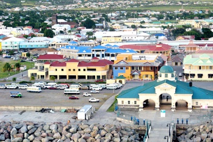
left: The spiffy-looking cruise terminal of St. Kitts.
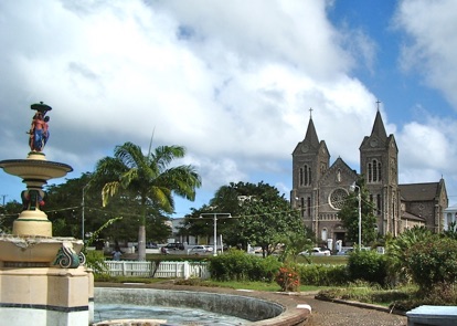
After disembarkation, we walked to Independence square, originally called Pall Mall square, and looked inside the cathedral.
On our way back we were accosted by Veronica, who was driving a minibus, and who offered us a tour of the island for US$16. But first she had to get more passengers to fill her van and she tirelessly approached everybody who looked like a good prospect. When we had ten passengers she started the tour. And she was still soliciting people on the street to join us. I guess she expected to fill two passengers to each seat of the van.
Traffic in Basseterre was heavy, but as soon as we were outside the city limit, there was much less traffic. Veronica was actually a pretty good guide, giving a lot of information and able to answer most questions about the area. She took us around the island in counterclockwise fashion.
There are 240 active churches on the island, and the main religious denominations are catholics and anglicans. The national bird is the pelican. The only industry is tourism. At one time sugar cane was a major commodity, but now the canes are rotting in the field, because it was not economical anymore to produce sugar from cane. An enterprising American managed to purchase 500 acres of fields covered with sugarcane on the North Coast at a very low price with the promise of creating employment. But no jobs materialized and he is just sitting on the property waiting for it to increase in value. A fence now surrounds the property.
left: The “Black Rocks” of St. Kitts.
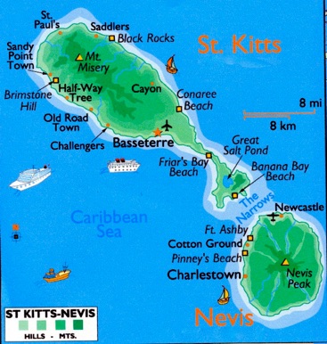
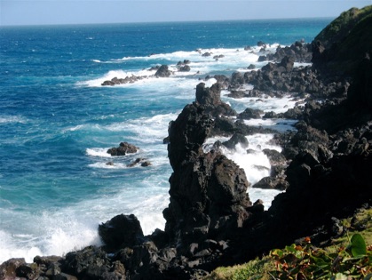
Our first stop was at the “Black Rocks” on the wild North Coast. For location see the map above. This portion of the wild coastline is covered with large black volcanic rocks from an eruption from nearby mount Liamuiga (known locally as Mt Misery) only 40,000 years ago.
The surf pounding on the shore is due to the prevailing trade winds. Huge volcanic rocks are seen all over the place in this area. From there we drove through the wet rainforest, which is also the source of water for the island. The area of St. Kitts is around 176 sq kms, but a quarter of it is rainforest.
The next stop was the Botanical Garden with many interesting and colorful plants. The Garden is in Romney Manor, once owned by the grandfather of Thomas Jefferson. It used to be the main building of a sugar estate, but nowadays it is home to Caribelle Batik. Here, artisans demonstrate the process of creating batik cloth, which are also available for sale. Their design are modern and very colorful.
In the Garden we were intrigued by the “lipstick” tree, where the fruit looks like the Indonesian rambutan. But if you split this oval fruit in two, you will find lots of seeds in it, which is used to color lips red. 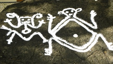
right: One of the many “Petroglyphs” on the island. The white color has not been added recently, but seems to be the original color still intact over the intervening centuries.
On the island one will also see quite a number of rock carvings or “petroglyphs”, as they are called there. They have been created by the original inhabitants prior to the arrival of the Europeans in the 17th century, and it appears that we still don’t quite know what they represent. Because of lack of time, we did not take the “Petroglyph trail”, which is very interesting. Well, maybe there is a next time.
We did drive by the Brimstone Hill Fortress, perched high above the sea level, but did not visit it, because it was too far away. Another attraction we missed is the St. Kitts Scenic Railway, the tourist double-decker Sugar Train, which trundles around the coastline.
The island did not look very prosperous at all; they actually looked on the poor side. An exception is Frigate Bay, close to Friar’s Bay Beach, a huge enclave of houses of rich Americans, anchored by a Marriott Hotel with a golf course. Frigate Bay is on the narrowest part of the island and from the hills you can see both the wild and cold Atlantic Ocean on the North shore and the placid Caribbean Sea on the South Shore. Frigate Bay is on the Caribbean Sea, obviously.
(c) Barbados
Barbados is a sovereign island in the British Commonwealth. It is part of the Lesser Antilles and it is about 34 kms in length and up to 23 kms in width. Barbados was claimed for the Spanish crown in the late 15th century, but later it became a British colony. In comparison to its neighbors the land is quite flat.
The country is considered to have a tropical monsoon climate, consisting of a “wet season”, from June to November, and a “dry season” from December to May.
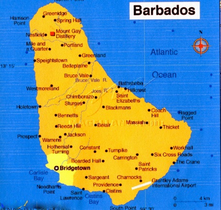
left: map of Barbados
The sun can be intensely hot, and cloudy days are nice, also because there is usually a gentle breeze.
The capital of Barbados is Bridgetown. The QE II could moor at the pier, but buses are provided to take the passengers to the cruise terminal in Bridgetown. They want to be sure you walk through the shopping center in the cruise terminal coming and going from the cruise ship.
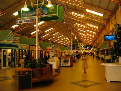
right: The gauntlet of tourist shops in the Barbados cruise terminal.
We rented a Jimmy car (looks like an old-style Jeep) from Stoutes Car Rental, which seems to be the only car rental agency on the island. Car rental is expensive, around US$ 100/day. They said this because taxes are a substantial portion of the rental. I suspect that having a monopoly also added to the rental they can charge you.
We drove North; the roads were OK but there are very few signs, and a lot of times we had to ask where we were. People are nice but drivers are not overly courteous, especially if they are driving the buses. Just like in the other Caribbean islands close by, the population was not very prosperous, but occasionally there is an enclave where super-rich people, mostly foreigners, live. On most of the roads it was difficult to overtake, and only a few drivers did we see do this rather recklessly.
We drove north through the Parish of St. Thomas, then past those of St. James, and then St Peter, the best for the last. We then crossed the island to get to the Atlantic Coast of the island. There the coast is rocky and inhospitable and the swells are large. We drove by the Barbados Wildlife Reserve, Farley Hill National Park, and Orchid World. But we did not enter any of these, because they did not look too attractive.
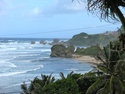
left: View of the wild north coast at Batsheba.
Finally, we drove past sand dunes, and then along the shore to Bathsheba, where we had lunch at the Round House Inn. There is nice view of the ocean from the dining room. In the surf you can see the big black rocks, which may be volcanic in origin. Lunch was a shared flying fish paté and a grilled flying fish entree. Yes, there are many flying fish there. The tab was 70 Barbados dollars which is about $35.
(d) St Lucia
St Lucia is a sovereign island country in the British Commonwealth of Nations, with Queen Elizabeth II as the titular Head of State represented on the island by the Governor-General. But executive power is in the hands of the locally elected prime minister and his cabinet.
The country is located in the Eastern Caribbean Sea and considered to be one of the Windward Islands. It has a land area of around 240 sq miles and population of the island is around 174,000. The capital is Castries.
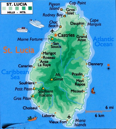
right: Map of St. Lucia.
St Lucia is quite mountainous, with the highest point being Mount Gimie, 3,120 feet above the sea level.
But their most famous mountains are the two Pitons, located between Soufrière and Choiseul. The Grande and the Petite Pitons are the landmark of the island. In 2008 Frommers listed this island as one of the top 14 vacation destination in the world.
The QM 2 had to moor some 1.5 miles out to sea from the port of Castries because of the shallow draft around the pier area. And the water in between these two points were very choppy that day. I had purchased a tour from ShoreTrips.com for $174 for two passengers. It was expensive and I could have done better getting a tour in the cruise terminal. But for this price Dave, the driver/guide did his best to show me as much as possible of the island. Norma was not feeling well and stayed on the boat that day and I was the only passenger in the 8-passenger van.
The island is mostly catholic, but Dave is unmarried but has a partner of 7 years with who he has a 5-year old daughter. She works in a hotel.
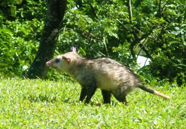
left: Big rats are seen gamboling on the grass.
Now the barracks have been converted to a junior college with some 3,000 students, but the site is still a National Trust Historic Area. A few cannons are still on the premises, but as befitting a British site, the grass was well-tended and green. What was interesting was that we saw a number of huge rats walking on the lawns.
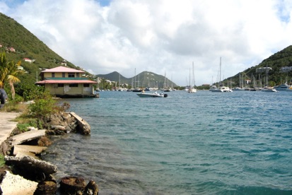
right: Beautiful Marigot Bay.
Shimmering in the distance was beautiful Marigot Bay . The villas on the far side of the Bay can only be accessed by water. There are no roads in the hills.
Admiral Rodney used to camouflage his warships with palm fronds and hide in the adjacent mangrove forest, to pounce on unsuspecting French frigates as they sailed by.
We passed a lot of banana plantations. Bananas are a major export item of the island. Yes, we have lots of bananas.
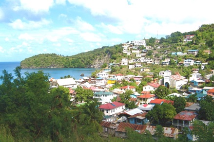
Our next stop was the picturesque fishing village of Anse La Raye.
left: Main street of Anse La Raye.
On this street is a long covered corridor with open-air stalls where, on Friday evenings, vendors with BBQ’d seafood, fish, mussels, lobsters, etc. set up shop. There is a band playing to enliven the scene and everyone has a good time.

right: And this is Anse La Raye from the top of the adjacent hill.
The next fishing village we drove by was Canaries, cute and picturesque. Only locals live here; no foreigners. The landscape is hilly with high mountains and deep gorges covered by lush vegetation.
We finally made it to Soufrière. The road through the mountains is curvy but is in pretty good condition. There are a few potholes, but the road is sometimes narrow in places, so driving takes a lot of time. You cannot go very fast.

left: The Grande and the Petite Pitons, landmark of the island.
Soufrière is an old French town on the Atlantic side of the island, and it used to be the capital of the island. Close by are the twin towers, the landmark of the island, the Grande and the Petite Piton.
And a bit further away is the “drive-in” volcano, a most unusual place. Some 40,000 years ago a huge cauldron, some 7 miles in diameter was formed because of a volcanic eruption. But then the East wall of this volcano fell away in the sea, and so now you can drive into the volcanic area with a car, certainly less strenuous than having to walk up the walls and going down again into the volcano.

right: Bubbling pots of mud and steam-expelling vents in the drive-in volcano.
In a number of place are bubbling mud pots and steam-expelling vents in the rocky walls. There is a slight smell of hydrogen sulfide, but the vegetation around was still verdant and healthy, showing that they were not affected by this gas.

left :Public bathing pool in the volcano area.
Downstream there is actually a public mud-bath, but time constraints did not permit me to enjoy this boon.

From there we raced to the Botanical Gardens, created in memory of their parents by the Devaux siblings more than a century ago. It is also called the Diamond Botanical Gardens. The Devaux are still the preeminent family on the island. In the Garden are many local flowers, as well as educational displays.
right: A red bridge in the lush Diamond Botanical Gardens
The hot springs in the volcano are also present in the garden and these are used for the mineral baths on the property. They were originally built in 1784 for the soldiers of Louis XVI of France for their therapeutic properties. The empress Josephine was also said to have used these baths when she was a young girl, because she was a cousin to the Devaux kids.

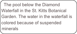
left: The beautiful colored Diamond Waterfall in the Botanical Garden.
There is also the Diamond Waterfall, some 100’ high, and looking as if it is spilling colored water, because the rocks behind the fall are colored red (iron oxide), black, white (sulphur), making the water slightly milky looking, because of the suspended mineral particles.
We caught the last tender leaving Castries to get back to the QM 2.
Wednesday, December 12, 2007